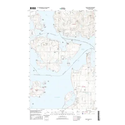
2017 Map of Shaw Island
USGS Topo · Published 2017About this map
Orcas, Shaw Island, and Lopez serve as the primary hubs for this island-dense portion of the San Juan archipelago. The map illustrates a complex network of maritime transit, including the Anacortes - Orcas Island Ferry and the Lopez Island - Shaw Island routes that weave through Harney Channel and Upright Channel. This modern topographical study captures the unique aviation infrastructure of the islands, from the Clam Harbor Airport on Orcas to the Wilding Farm Airport on Shaw and the Windsock Airport on Lopez. Inland, the landscape is punctuated by freshwater bodies like Killebrew Lake and Hummel Lake, while the coastline is defined by protected anchorages such as Grindstone Harbor and Fisherman Bay. Higher elevations at Mt Woolard and Diamond Hill provide a vertical contrast to the low-lying points and reefs like Minnesota Reef and Reid Rock.
Find a feature on this map
73 named features on this map. Tap any name to fly to it.
Don’t see what you’re looking for? This feature index may not catch every label — zoom into the map to look around manually.
Map Details
Editions of this 2017 Shaw Island Map
This is the sole edition of this map. No revisions or reprints were ever made.
Other maps of this area

1943 · Richardson
USGS Topo · 1:62,500

1943 · Orcas Island
USGS Topo · 1:62,500

1954 · Waldron Island
USGS Topo · 1:24,000

1954 · Friday Harbor
USGS Topo · 1:24,000

1954 · False Bay
USGS Topo · 1:24,000

1957 · Richardson
USGS Topo · 1:62,500

1957 · Orcas Island
USGS Topo · 1:62,500

1957 · Victoria
USGS Topo · 1:250,000
1973 · Lopez Pass
USGS Topo · 1:24,000

1973 · Shaw Island
USGS Topo · 1:24,000