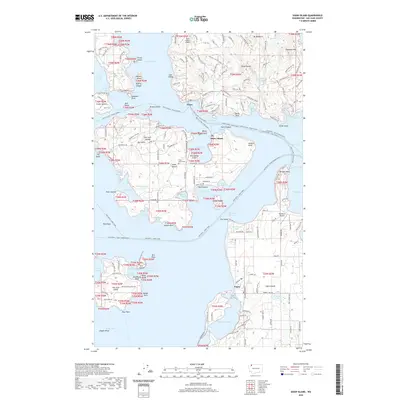
2020 Map of Shaw Island
USGS Topo · Published 2020About this map
Shaw Island and the surrounding San Juan Islands are defined by a complex network of coastal features and maritime infrastructure. The map details the intricate waterways of the San Juan Channel and Wasp Passage, where the reliance on water travel is evident through the numerous ferry routes, including the Anacortes - Orcas Island Ferry. Small-scale aviation also plays a critical role in regional connectivity, with private strips like Clam Harbor Airport, Wilding Farm Airport, and Windsock Airport serving the islands. Inland, the landscape features landmarks such as Ben Nevis and Mt Woolard, alongside localized agrarian sites like the Bar Nothing Ranch. The presence of the Shaw Island Cem and established settlements at Orcas and Lopez provide specific points of interest for genealogists and local historians tracking the development of these island communities. Small water bodies, such as Hummel Lake and Killebrew Lake, dot the interior, providing freshwater resources amidst the saltwater sound.
Find a feature on this map
184 named features on this map. Tap any name to fly to it.
Don’t see what you’re looking for? This feature index may not catch every label — zoom into the map to look around manually.
Map Details
Editions of this 2020 Shaw Island Map
This is the sole edition of this map. No revisions or reprints were ever made.
Other maps of this area

1943 · Richardson
USGS Topo · 1:62,500

1943 · Orcas Island
USGS Topo · 1:62,500

1954 · Waldron Island
USGS Topo · 1:24,000

1954 · Friday Harbor
USGS Topo · 1:24,000

1954 · False Bay
USGS Topo · 1:24,000

1957 · Richardson
USGS Topo · 1:62,500

1957 · Orcas Island
USGS Topo · 1:62,500

1957 · Victoria
USGS Topo · 1:250,000
1973 · Lopez Pass
USGS Topo · 1:24,000

1973 · Shaw Island
USGS Topo · 1:24,000