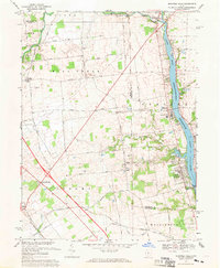
1967 Map of Shawnee Hills
USGS Topo · Published 1969About this map
The O'Shaughnessy Reservoir and the Scioto River corridor dominate this late 1960s landscape, serving as a focal point for the region's geography and infrastructure. The O'Shaughnessy Dam Spillway anchors the southern end of the water body, while the surrounding townships like Jerome and Concord show a transition from traditional rural agriculture toward modern development. Family and community histories are preserved in numerous small burial grounds, including Bouic Cem, Oller Cem, and Watkins Cem.
Find a feature on this map
49 named features on this map. Tap any name to fly to it.
Don’t see what you’re looking for? This feature index may not catch every label — zoom into the map to look around manually.
Map Details
Editions of this 1967 Shawnee Hills Map
4 editions found
Other maps of this area

1901 · Dublin
USGS Topo · 1:62,500

1903 · Dublin
USGS Topo · 1:62,500

1913 · Richwood
USGS Topo · 1:62,500

1915 · Richwood
USGS Topo · 1:62,500

1916 · Milford Center
USGS Topo · 1:62,500

1924 · Delaware
USGS Topo · 1:62,500

1925 · Delaware
USGS Topo · 1:62,500

1944 · Richwood
USGS Topo · 1:62,500

1944 · Milford Center
USGS Topo · 1:62,500

1944 · Delaware
USGS Topo · 1:62,500