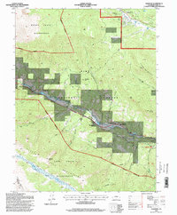
1994 Map of Shawnee
USGS Topo · Published 1998About this map
The South Fork Platte River carves a central valley through this high-altitude landscape, anchoring the settlements of Shawnee and Glenisle. In the 1990s, this corridor served as a vital educational hub for the region, housing both Jesse B Fitzsimmons Middle School and Platte Canyon High School. To the north and south, the terrain rises sharply into protected lands, defined by the Mount Evans Wilderness and the Lost Creek Wilderness. A complex network of drainage gulches, including Slaughterhouse Gulch and Crow Gulch, feeds into the river valley, while established routes like the Ben Tyler Trail and Brookside Trail provide access to the surrounding Kenosha Mountains. Historical ranching and administrative activity is evidenced by the AG Ranch Work Center, positioned near the river's bend.
Find a feature on this map
43 named features on this map. Tap any name to fly to it.
Don’t see what you’re looking for? This feature index may not catch every label — zoom into the map to look around manually.
Map Details
Editions of this 1994 Shawnee Map
This is the sole edition of this map. No revisions or reprints were ever made.
Other maps of this area

1893 · Platte Canyon
USGS Topo · 1:125,000

1899 · West Denver
USGS Topo · 1:125,000

1903 · Georgetown
USGS Topo · 1:62,500

1905 · Georgetown
USGS Topo · 1:62,500

1945 · Bailey
USGS Topo · 1:24,000

1945 · Shawnee
USGS Topo · 1:24,000

1945 · Mount Logan
USGS Topo · 1:24,000

1948 · Mount Logan
USGS Topo · 1:24,000

1948 · Shawnee
USGS Topo · 1:24,000

1949 · Bailey
USGS Topo · 1:24,000