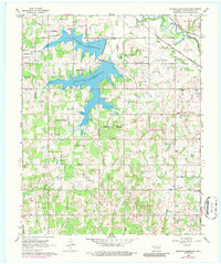
1966 Map of Shawnee Reservoir
USGS Topo · Published 1986About this map
The Shawnee Reservoir dominates the landscape of this Pottawatomie County region, its jagged fingers stretching across the townships of Bales Twp and Brinton. By the mid-1960s, the area's infrastructure reflects a transition from rural agriculture to specialized industry and recreation, with several Oil Wells and Gas Wells appearing near the reservoir’s western banks. The northern reach is defined by the Canadian River and a significant rail corridor where the Chicago Rock Island and Pacific and Atchison Topeka and Santa Fe railroads converge near Mc Loud. Local history and genealogy interest is concentrated in smaller communities like Bethel Acres and long-standing landmarks such as Blackburn Chapel and the Newhope Sch. The map also captures several rural burial grounds, including Ray Cem and Brown Cem, providing a spatial record of the county’s settlement patterns prior to late-century suburban expansion.
Find a feature on this map
31 named features on this map. Tap any name to fly to it.
Don’t see what you’re looking for? This feature index may not catch every label — zoom into the map to look around manually.
Map Details
Editions of this 1966 Shawnee Reservoir Map
3 editions found
Other maps of this area

1896 · Seminole and Prague
USGS Topo · 1:125,000

1898 · Purcell
USGS Topo · 1:125,000

1907 · Maud
USGS Topo · 1:62,500

1908 · Maud
USGS Topo · 1:62,500

1909 · Shawnee
USGS Topo · 1:62,500

1910 · McComb
USGS Topo · 1:62,500

1930 · McLoud
USGS Topo · 1:62,500

1954 · Oklahoma City
USGS Topo · 1:250,000

1956 · Harrah
USGS Topo · 1:24,000
1956 · Stella
USGS Topo · 1:24,000