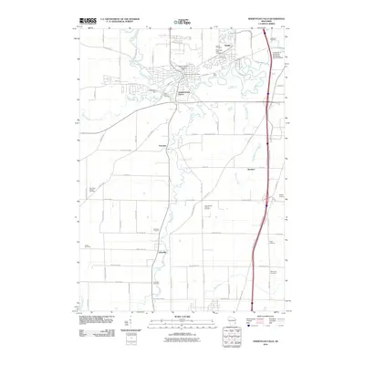
2010 Map of Sheboygan Falls
USGS Topo · Published 2010About this map
The Sheboygan River winds through the heart of this landscape, its power harnessed by the Dassow Milling Company Dam and the Richardson Dam. These waterworks define the industrial heritage of Sheboygan Falls, where the Sheboygan Falls Post Office serves a community anchored by its proximity to the Onion River and Mullet River. The map reveals a transition from the structured street grids of Kohler and the University of Wisconsin-Sheboygan County Campus to the expansive agricultural tracts surrounding Ourtown and Gibbsville. Genealogists will find a concentration of burial sites throughout the quadrangle, including the Saint Marys Cemetery, Saint George Catholic Cemetery, and the Flader Cemetery. The presence of the Gibbsville Orchard and the Hilbes Airport further illustrates the varied land use of this Wisconsin region at the start of the twenty-first century.
Find a feature on this map
82 named features on this map. Tap any name to fly to it.
Don’t see what you’re looking for? This feature index may not catch every label — zoom into the map to look around manually.
Map Details
Editions of this 2010 Sheboygan Falls Map
This is the sole edition of this map. No revisions or reprints were ever made.
Other maps of this area

1954 · Sheboygan Falls
USGS Topo · 1:62,500

1954 · Sheboygan South
USGS Topo · 1:62,500

1954 · Sheboygan Falls
USGS Topo · 1:24,000

1954 · Sheboygan North
USGS Topo · 1:62,500

1954 · Sheboygan North
USGS Topo · 1:24,000

1954 · Sheboygan South
USGS Topo · 1:24,000

1954 · Howards Grove
USGS Topo · 1:62,500

1954 · Howards Grove
USGS Topo · 1:24,000

1954 · Franklin
USGS Topo · 1:24,000

1954 · Milwaukee
USGS Topo · 1:250,000