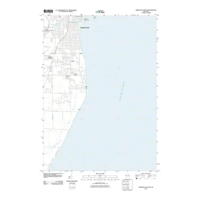
2010 Map of Sheboygan South
USGS Topo · Published 2010About this map
Sheboygan anchors this coastal landscape where the Sheboygan River meets Lake Michigan. The map illustrates a developed lakefront defined by industrial and maritime infrastructure, including the Sheboygan Port + Warehouse Terminal, Limited and the South Pierhead Light. Stretching south from the city center, the terrain transitions into the residential area of Indian Meadows and the open spaces of the Riverdale Public Golf Course and Camp Taswood. Local history is preserved in several major burial grounds such as Wildwood Cemetery, Southside Cemetery, and the Immaculate Conception Cemetery. The Black River meanders parallel to the shoreline through the southern portion of the sheet, eventually reaching the prominent Black River Point. This 2010 edition also captures the University of Wisconsin-Sheboygan County Campus, serving as a modern educational landmark for the region.
Find a feature on this map
23 named features on this map. Tap any name to fly to it.
Don’t see what you’re looking for? This feature index may not catch every label — zoom into the map to look around manually.
Map Details
Editions of this 2010 Sheboygan South Map
This is the sole edition of this map. No revisions or reprints were ever made.
Other maps of this area

1954 · Sheboygan Falls
USGS Topo · 1:62,500

1954 · Sheboygan South
USGS Topo · 1:62,500

1954 · Sheboygan Falls
USGS Topo · 1:24,000

1954 · Sheboygan North
USGS Topo · 1:62,500

1954 · Sheboygan North
USGS Topo · 1:24,000

1954 · Sheboygan South
USGS Topo · 1:24,000

1954 · Howards Grove
USGS Topo · 1:62,500

1954 · Howards Grove
USGS Topo · 1:24,000

1954 · Milwaukee
USGS Topo · 1:250,000

1958 · Milwaukee
USGS Topo · 1:250,000