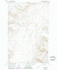
1965 Map of Sheep Coulee
USGS Topo · Published 1987About this map
The Sun Prairie Flats dominate this Phillips County landscape, illustrating a wide expanse of Montana grassland as it appeared in the mid-1960s. Surveyed by the U.S. Geological Survey as part of a development program for the Missouri River Basin, the map reveals a terrain defined by subtle drainage patterns and seasonal watercourses. The network of coulees and creeks, including Sheep Coulee and Little Sevenmile Creek, provides a clear view of the natural hydrology that shaped local ranching and land use before late-20th-century developments. Key geographic markers such as The Big Sag Flat Creek and Box Elder Coulee highlight the intricate topographical variations within the prairie. This document, later updated in the 1980s with photogrammetric revisions, remains an essential resource for understanding the rural character and landform distribution of this northern plains region.
Find a feature on this map
8 named features on this map. Tap any name to fly to it.
Don’t see what you’re looking for? This feature index may not catch every label — zoom into the map to look around manually.
Map Details
Editions of this 1965 Sheep Coulee Map
2 editions found

Other maps of this area

1954 · Jordan
USGS Topo · 1:250,000

1954 · Glasgow
USGS Topo · 1:250,000

1956 · Jordan
USGS Topo · 1:250,000

1957 · Glasgow
USGS Topo · 1:250,000

1958 · Glasgow
USGS Topo · 1:250,000

1958 · Jordan
USGS Topo · 1:250,000

1964 · Jordan
USGS Topo · 1:250,000

1965 · Coal Mine Hill
USGS Topo · 1:24,000

1965 · Sun Prairie
USGS Topo · 1:24,000

1965 · Whitcomb Lake
USGS Topo · 1:24,000