
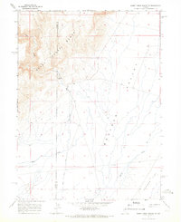
1965 Map of Sheep Creek Range SE
USGS Topo · Published 1967About this map
The high desert divide of the Black Rock Range and the alluvial expanse of Boulder Valley define this mid-1960s landscape along the border of Lander and Eureka counties. Water management and hydrological monitoring are central to the activity in this arid corridor, evidenced by a Gaging Station on Rock Creek and a localized Ditch system. The map captures a moment when traditional ranching or agricultural infrastructure relied on the seasonal flows of ephemeral watercourses like Boulder Creek. The stark transition from the steep contours of the western mountains to the broad, flat basin illustrates the drainage patterns essential to Great Basin geography before modern developments might have altered these rural water rights and paths.
Find a feature on this map
7 named features on this map. Tap any name to fly to it.
Don’t see what you’re looking for? This feature index may not catch every label — zoom into the map to look around manually.
Map Details
Editions of this 1965 Sheep Creek Range SE Map
2 editions found
Other maps of this area

1955 · Winnemucca
USGS Topo · 1:250,000

1957 · Dunphy
USGS Topo · 1:62,500

1957 · Beowawe
USGS Topo · 1:62,500

1958 · Winnemucca
USGS Topo · 1:250,000

1962 · Winnemucca
USGS Topo · 1:250,000

1965 · Sheep Creek Range SW
USGS Topo · 1:24,000

1965 · Sheep Creek Range NE
USGS Topo · 1:24,000

1965 · Sheep Creek Range NW
USGS Topo · 1:24,000

1968 · Rodeo Creek SW
USGS Topo · 1:24,000

1968 · Rodeo Creek NW
USGS Topo · 1:24,000