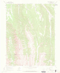
1963 Map of Sheep Mountain
USGS Topo · Published 1969About this map
Uncompahgre National Forest dominates this mountain landscape, defined by high-elevation ridges and the deep drainages of the Cimarron and Big Blue systems. The map illustrates a high-country economy reliant on seasonal grazing and forest management in the early 1960s, evidenced by the Ridge Stock Driveway and the Alpine Guard Sta. Remote landmarks like Sheep Mountain and Van Boxel anchor the rugged topography, while the Alpine Trail (Pack) and Firebox Trail (Pack) provide the primary means of traversal through the timbered slopes. Recreational and administrative sites such as the Big Blue Campground and Johnson Park sit near the boundaries of Gunnison and Hinsdale Counties, showing the intersection of local government oversight and federal land use in the Colorado high country.
Find a feature on this map
21 named features on this map. Tap any name to fly to it.
Don’t see what you’re looking for? This feature index may not catch every label — zoom into the map to look around manually.
Map Details
Editions of this 1963 Sheep Mountain Map
4 editions found
Other maps of this area

1902 · Ouray
USGS Topo · 1:62,500

1903 · Lake City
USGS Topo · 1:62,500

1904 · Ouray
USGS Topo · 1:62,500

1905 · Lake City
USGS Topo · 1:62,500

1908 · Uncompahgre
USGS Topo · 1:125,000

1909 · Montrose
USGS Topo · 1:125,000

1911 · Uncompahgre
USGS Topo · 1:125,000

1911 · Montrose
USGS Topo · 1:125,000

1956 · Montrose
USGS Topo · 1:250,000

1959 · Montrose
USGS Topo · 1:250,000