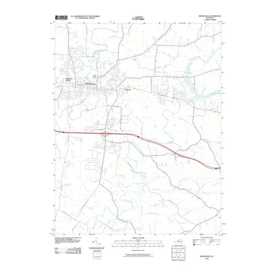
2010 Map of Shelbyville
USGS Topo · Published 2010About this map
Shelbyville serves as the central hub of this northern Kentucky landscape, where the confluence of historic road networks and winding waterways like Clear Creek and Mulberry Creek define the local geography. The area's development is evident in the residential clusters at Middletown Heights and Veachland, while the eastern portion of the map is dominated by the extensive reach of Guist Creek Lake. This 2010 survey illustrates a complex transition from the urban core to the surrounding agricultural and recreational lands, notably the green spaces near Shelby Lake. Genealogists and local historians can pinpoint significant landmarks such as the Saffell Calvary Cemetery, and trace the paths of secondary routes including McMakin-McMullen Rd and Zaring Mill Rd as they navigate the drainages of Jeptha Creek and Wolf Run.
Find a feature on this map
29 named features on this map. Tap any name to fly to it.
Don’t see what you’re looking for? This feature index may not catch every label — zoom into the map to look around manually.
Map Details
Editions of this 2010 Shelbyville Map
This is the sole edition of this map. No revisions or reprints were ever made.
Other maps of this area

1923 · Waddy
USGS Topo · 1:48,000

1925 · Mount Eden
USGS Topo · 1:48,000

1927 · Mount Eden
USGS Topo · 1:62,500

1928 · New Castle
USGS Topo · 1:48,000

1929 · Taylorsville
USGS Topo · 1:62,500

1932 · New Castle
USGS Topo · 1:62,500

1932 · La Grange
USGS Topo · 1:62,500

1954 · Ballardsville
USGS Topo · 1:24,000
1954 · Glensboro
USGS Topo · 1:24,000

1954 · Taylorsville
USGS Topo · 1:24,000