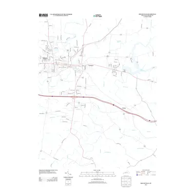
2013 Map of Shelbyville
USGS Topo · Published 2013About this map
Guist Creek Lake dominates the eastern landscape of this Shelby County study, its fingers reaching into the surrounding terrain near Hooper. The area's settlement pattern is anchored by Middletown Heights and Veachland, showing the residential development patterns of the early 21st century. Significant watercourses like Clear Creek and Guist Creek define the drainage of this bluegrass region, while the local geography is punctuated by elevations such as Snow Hill. Local history is preserved in sites like Calvary Cemetery, situated near the intersection of several established roadways. The network of smaller runs and branches, including Britton Run and Meadow Run, illustrates the complex hydrological system that has shaped the county's agricultural and suburban identity.
Find a feature on this map
120 named features on this map. Tap any name to fly to it.
Don’t see what you’re looking for? This feature index may not catch every label — zoom into the map to look around manually.
Map Details
Editions of this 2013 Shelbyville Map
This is the sole edition of this map. No revisions or reprints were ever made.
Other maps of this area

1923 · Waddy
USGS Topo · 1:48,000

1925 · Mount Eden
USGS Topo · 1:48,000

1927 · Mount Eden
USGS Topo · 1:62,500

1928 · New Castle
USGS Topo · 1:48,000

1929 · Taylorsville
USGS Topo · 1:62,500

1932 · New Castle
USGS Topo · 1:62,500

1932 · La Grange
USGS Topo · 1:62,500

1954 · Ballardsville
USGS Topo · 1:24,000
1954 · Glensboro
USGS Topo · 1:24,000

1954 · Taylorsville
USGS Topo · 1:24,000