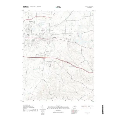
2019 Map of Shelbyville
USGS Topo · Published 2019About this map
Shelbyville serves as the central hub for this Kentucky landscape, where the dense grid of the city center transitions into the suburban reaches of Middletown Heights and the outlying communities of Veachland and Hooper. The geography is defined by a dense network of watercourses, most notably the meandering Clear Creek and the expansive Guist Creek reservoir system, which dominates the eastern half of the quadrangle. For those researching local heritage, the map identifies significant land use markers such as the Grove Hill Cem and Saffell Calvary Cem, alongside recreational landmarks like Lake Shelby. The terrain is characterized by subtle elevations like Snow Hill and the intricate drainage basins of Jeptha Cr and Britton Run, illustrating the complex interplay between the region's natural hydrology and modern infrastructure like the Three Mile Bridge.
Find a feature on this map
114 named features on this map. Tap any name to fly to it.
Don’t see what you’re looking for? This feature index may not catch every label — zoom into the map to look around manually.
Map Details
Editions of this 2019 Shelbyville Map
This is the sole edition of this map. No revisions or reprints were ever made.
Other maps of this area

1923 · Waddy
USGS Topo · 1:48,000

1925 · Mount Eden
USGS Topo · 1:48,000

1927 · Mount Eden
USGS Topo · 1:62,500

1928 · New Castle
USGS Topo · 1:48,000

1929 · Taylorsville
USGS Topo · 1:62,500

1932 · New Castle
USGS Topo · 1:62,500

1932 · La Grange
USGS Topo · 1:62,500

1954 · Ballardsville
USGS Topo · 1:24,000
1954 · Glensboro
USGS Topo · 1:24,000

1954 · Taylorsville
USGS Topo · 1:24,000