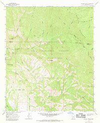
1965 Map of Shelley Peak
USGS Topo · Published 1969About this map
Shelley Peak stands as the central landmark of this mid-1960s survey, documenting a portion of the Mogollon Mountains where the Catron and Grant County line runs through high-elevation terrain. This area is characterized by an extensive network of drainage systems, including Lookout Canyon, South Fork Canyon, and Skeleton Canyon, all feeding into the Mogollon Creek watershed.
Find a feature on this map
36 named features on this map. Tap any name to fly to it.
Don’t see what you’re looking for? This feature index may not catch every label — zoom into the map to look around manually.
Map Details
Editions of this 1965 Shelley Peak Map
2 editions found
Other maps of this area

1910 · Mogollon
USGS Topo · 1:125,000

1911 · Alum Mountain
USGS Topo · 1:125,000

1912 · Mogollon
USGS Topo · 1:125,000

1913 · Alum Mountain
USGS Topo · 1:125,000

1954 · Clifton
USGS Topo · 1:250,000

1957 · Clifton
USGS Topo · 1:250,000

1958 · Clifton
USGS Topo · 1:250,000

1962 · Clifton
USGS Topo · 1:250,000
1965 · Canteen Canyon
USGS Topo · 1:24,000
1965 · Diablo Range
USGS Topo · 1:24,000