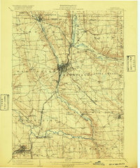
1908 Map of Shenango
USGS Topo · Published 1920About this map
Greenville serves as a central hub in this early twentieth-century survey of Mercer County, situated where the Shenango River meets the Bessemer and Lake Erie railroad. The landscape is defined by the transition from water-borne transport to rail, most notably marked by the Beaver and Erie Canal (Abandoned) winding alongside the river toward Sharpsville. This era reveals a densely settled rural fabric of family-named schools and crossroads, such as Kammerer School, Artman School, and Leech's Cors.
Find a feature on this map
73 named features on this map. Tap any name to fly to it.
Don’t see what you’re looking for? This feature index may not catch every label — zoom into the map to look around manually.
Map Details
Editions of this 1908 Shenango Map
5 editions found
Other maps of this area

1905 · Andover
USGS Topo · 1:48,000

1905 · Neshannock
USGS Topo · 1:62,500

1906 · Linesville
USGS Topo · 1:62,500

1906 · Youngstown
USGS Topo · 1:62,500

1907 · Andover
USGS Topo · 1:62,500

1907 · Neshannock
USGS Topo · 1:62,500

1907 · Kinsman
USGS Topo · 1:62,500

1908 · Shenango
USGS Topo · 1:62,500

1908 · Linesville
USGS Topo · 1:62,500

1908 · Youngstown
USGS Topo · 1:62,500