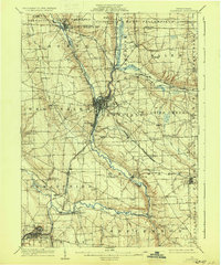
1908 Map of Shenango
USGS Topo · Published 1933About this map
The Shenango River corridor serves as the industrial and logistical spine of this Mercer County landscape, where the confluence of the Little Shenango River and several major rail lines established Greenville as a significant regional hub. This 1908 survey documents an era when the river valley was densely networked with competing railroads, including the Erie, the Pennsylvania Lines, and the Bessemer and Lake Erie. These tracks link industrial centers like Sharpsville with rural junctions such as Transfer and Jamestown.
Find a feature on this map
78 named features on this map. Tap any name to fly to it.
Don’t see what you’re looking for? This feature index may not catch every label — zoom into the map to look around manually.
Map Details
Editions of this 1908 Shenango Map
5 editions found
Other maps of this area

1905 · Andover
USGS Topo · 1:48,000

1905 · Neshannock
USGS Topo · 1:62,500

1906 · Linesville
USGS Topo · 1:62,500

1906 · Youngstown
USGS Topo · 1:62,500

1907 · Andover
USGS Topo · 1:62,500

1907 · Neshannock
USGS Topo · 1:62,500

1907 · Kinsman
USGS Topo · 1:62,500

1908 · Shenango
USGS Topo · 1:62,500

1908 · Linesville
USGS Topo · 1:62,500

1908 · Youngstown
USGS Topo · 1:62,500