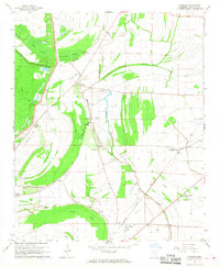
1967 Map of Sherard
USGS Topo · Published 1968About this map
Sherard and Bobo anchor this landscape of the Mississippi Delta, where the Illinois Central railroad and an intricate network of waterways define the local geography. The map reveals a community deeply rooted in its rural spiritual and educational centers, featuring numerous landmarks such as Sherard Sch, Sycamore Grove Ch, and Shiloh Ch. The area is marked by a complex system of bayous and wetlands, including Harris Bayou, Dogwood Bayou, and the expansive Annis Brake, illustrating the drainage patterns essential to this agricultural region.
Find a feature on this map
42 named features on this map. Tap any name to fly to it.
Don’t see what you’re looking for? This feature index may not catch every label — zoom into the map to look around manually.
Map Details
Editions of this 1967 Sherard Map
This is the sole edition of this map. No revisions or reprints were ever made.
Other maps of this area

1908 · Coahoma
USGS Topo · 1:24,000

1910 · Coahoma
USGS Topo · 1:31,680

1930 · Mellwood
USGS Topo · 1:62,500

1935 · Clarksdale
USGS Topo · 1:62,500

1939 · Farrell
USGS Topo · 1:62,500

1939 · Modoc
USGS Topo · 1:62,500

1939 · Clarksdale
USGS Topo · 1:62,500

1939 · Mellwood
USGS Topo · 1:62,500

1948 · Helena
USGS Topo · 1:250,000

1948 · Modoc
USGS Topo · 1:62,500