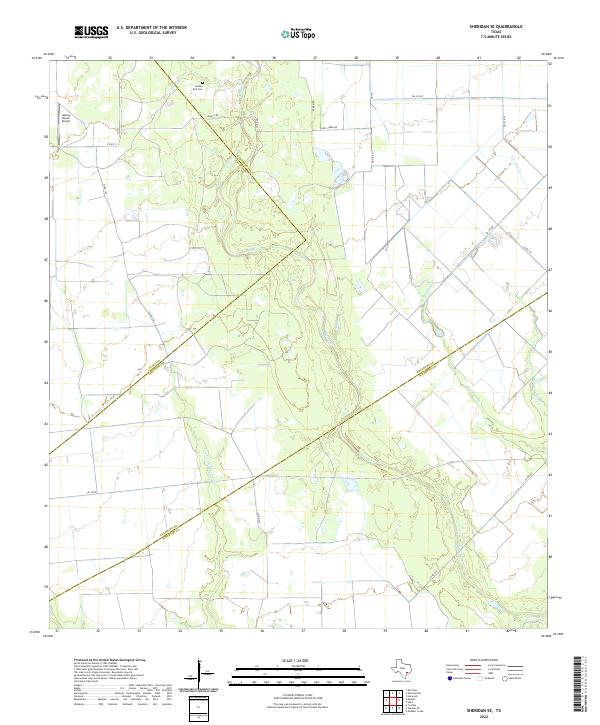
2022 Map of Sheridan SE
USGS Topo · Published 2022About this map
The convergence of three Texas counties—Colorado, Lavaca, and Wharton—dictates the landscape of this rural survey. The terrain is defined by the winding course of Sandy Creek, which meanders southeast toward the Wharton County line, and a complex network of tributaries including East Turkey Creek and Middle Turkey Creek. This area maintains a sparse, ranch-oriented character where aviation and agriculture intersect at the Galaxy Ranch Airport in the northwest corner.
Find a feature on this map
24 named features on this map. Tap any name to fly to it.
Don’t see what you’re looking for? This feature index may not catch every label — zoom into the map to look around manually.
Map Details
Editions of this 2022 Sheridan SE Map
This is the sole edition of this map. No revisions or reprints were ever made.
Other maps of this area

1953 · Seguin
USGS Topo · 1:250,000

1958 · Seguin
USGS Topo · 1:250,000

1959 · Garwood
USGS Topo · 1:24,000

1964 · Cordele
USGS Topo · 1:24,000

1964 · Speaks
USGS Topo · 1:24,000
1965 · Sheridan NE
USGS Topo · 1:24,000

1965 · Ganado NE
USGS Topo · 1:24,000

1965 · Sheridan SE
USGS Topo · 1:24,000

1965 · Gobbler Creek
USGS Topo · 1:24,000
1965 · Sheridan
USGS Topo · 1:24,000