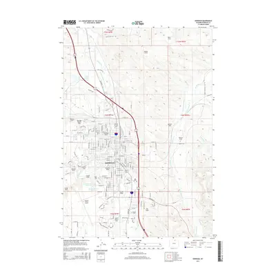
2015 Map of Sheridan
USGS Topo · Published 2015About this map
Sheridan serves as the focal point of this 2015 survey, revealing a landscape where the historic cattle-ranching heritage of the Bighorn Mountains foothills meets modern expansion. The town is intricately linked to its water sources, with the Big Goose Creek and Little Goose Creek converging near the center. Surrounding the city, a sophisticated network of irrigation features like the Grinnell Livestock Company Ditch, Soldier Creek Ditch, and Alliance Lateral speak to the region's enduring agricultural foundations. The presence of Sheridan College and the Sheridan County Airport at the southern edge of town marks the modern institutional footprint. Notable landmarks for local history include Mount Hope Cemetery and several named draws and gulches, such as Deadman Gulch and Hamma Draw, which define the local topography between the suburban developments and the open range.
Find a feature on this map
59 named features on this map. Tap any name to fly to it.
Don’t see what you’re looking for? This feature index may not catch every label — zoom into the map to look around manually.
Map Details
Editions of this 2015 Sheridan Map
This is the sole edition of this map. No revisions or reprints were ever made.
Other maps of this area

1895 · Dayton
USGS Topo · 1:125,000

1901 · Dayton
USGS Topo · 1:125,000

1909 · Sheridan
USGS Topo · 1:125,000

1911 · Sheridan
USGS Topo · 1:125,000

1955 · Sheridan
USGS Topo · 1:250,000

1958 · Sheridan
USGS Topo · 1:250,000

1962 · Sheridan
USGS Topo · 1:250,000
1964 · Monarch
USGS Topo · 1:24,000
1964 · Hultz Draw
USGS Topo · 1:24,000
1964 · Beaver Creek Hills
USGS Topo · 1:24,000