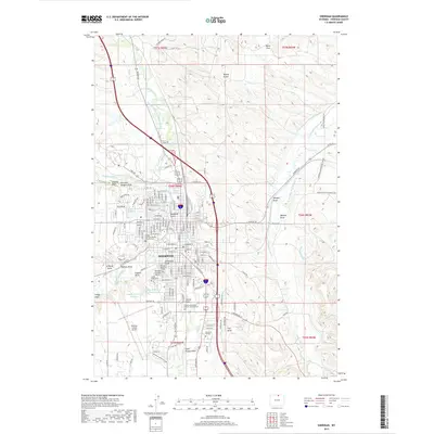
2017 Map of Sheridan
USGS Topo · Published 2017About this map
Sheridan dominates this 2017 landscape, showing the city's modern street grid and institutional anchors like Sheridan College and the Sheridan County Airport. The settlement's historical depth is visible in the placement of the Sheridan Municipal Cem and Mount Hope Cem, alongside faith-based landmarks such as the Trinity Lutheran Church Columbarium. The map reveals a complex water management system essential to this high-plains environment, featuring the Grindell Livestock Company Ditch, Soldier Cr Ditch, and Nine-mile Ditch. These man-made channels, along with Goose Creek and Little Goose Cr, illustrate the enduring importance of irrigation and water rights in Wyoming's development. Terrain features like Thunder Ridge and Beatty Gulch frame the urban expansion, while named draws such as Demple Draw and Hunter Draw mark the drainage patterns that have shaped the region's topography and land use.
Find a feature on this map
86 named features on this map. Tap any name to fly to it.
Don’t see what you’re looking for? This feature index may not catch every label — zoom into the map to look around manually.
Map Details
Editions of this 2017 Sheridan Map
This is the sole edition of this map. No revisions or reprints were ever made.
Other maps of this area

1895 · Dayton
USGS Topo · 1:125,000

1901 · Dayton
USGS Topo · 1:125,000

1909 · Sheridan
USGS Topo · 1:125,000

1911 · Sheridan
USGS Topo · 1:125,000

1955 · Sheridan
USGS Topo · 1:250,000

1958 · Sheridan
USGS Topo · 1:250,000

1962 · Sheridan
USGS Topo · 1:250,000
1964 · Monarch
USGS Topo · 1:24,000
1964 · Hultz Draw
USGS Topo · 1:24,000
1964 · Beaver Creek Hills
USGS Topo · 1:24,000