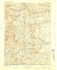
1905 Map of Sherman
USGS Topo · Published 1925About this map
High-altitude ranching and the critical transit corridors of the Laramie Mountains define this landscape at the turn of the century. The Union Pacific RR cuts across the southern portion of the map, passing through the high point of Sherman and the Ames Monument, while the Colorado and Southern RR moves through the eastern foothills near Islay Sta. This era represents a period of intensive land use by early Wyoming settlers, evidenced by the high density of family-run operations such as Benders Ranch, Mc Donalds Ranch, and Shavers Ranch.
Find a feature on this map
89 named features on this map. Tap any name to fly to it.
Don’t see what you’re looking for? This feature index may not catch every label — zoom into the map to look around manually.
Map Details
Editions of this 1905 Sherman Map
4 editions found
Other maps of this area

1895 · Laramie
USGS Topo · 1:125,000

1902 · Laramie
USGS Topo · 1:125,000

1905 · Sherman
USGS Topo · 1:125,000

1905 · Laramie
USGS Topo · 1:125,000

1906 · Laramie
USGS Topo · 1:125,000

1907 · Livermore
USGS Topo · 1:125,000

1908 · Laramie
USGS Topo · 1:125,000

1908 · Eaton
USGS Topo · 1:125,000

1909 · Livermore
USGS Topo · 1:125,000

1910 · Eaton
USGS Topo · 1:125,000