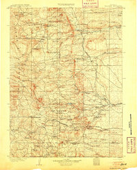
1905 Map of Sherman
USGS Topo · Published 1932About this map
The Sherman Mountains and the high ridges of the Laramie Mountains dominate this early 20th-century landscape, serving as a backdrop for the early expansion of the American West. The survey highlights the high-elevation passage of the Union Pacific RR across the rugged divide, marked by the monolithic Ames Monument and several ranching outposts like Sherman and Leslie. The region's early industrial efforts are visible at the Strong Coppermine and the settlement of Silver Crown, while the intricate network of the Crow Creek and Lodgepole Creek drainage systems supported a dense concentration of homesteads. Local family names are etched across the map, from Carey Ranch in the north to the McLaughlin Ranch and Whitakers Ranch, illustrating the transition from open range to established ranching territories just north of the Wyoming Colorado Boundary Line.
Find a feature on this map
90 named features on this map. Tap any name to fly to it.
Don’t see what you’re looking for? This feature index may not catch every label — zoom into the map to look around manually.
Map Details
Editions of this 1905 Sherman Map
4 editions found
Other maps of this area

1895 · Laramie
USGS Topo · 1:125,000

1902 · Laramie
USGS Topo · 1:125,000

1905 · Sherman
USGS Topo · 1:125,000

1905 · Laramie
USGS Topo · 1:125,000

1906 · Laramie
USGS Topo · 1:125,000

1907 · Livermore
USGS Topo · 1:125,000

1908 · Laramie
USGS Topo · 1:125,000

1908 · Eaton
USGS Topo · 1:125,000

1909 · Livermore
USGS Topo · 1:125,000

1910 · Eaton
USGS Topo · 1:125,000