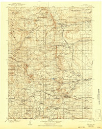
1905 Map of Sherman
USGS Topo · Published 1943About this map
The Laramie Mountains and Sherman Mountains define this high-altitude landscape during the early twentieth century. The map centers on the high pass where the Union Pacific RR crosses the range near the Ames Monument, a significant waypoint for transcontinental travel. This era shows a ranching-heavy economy, with family-named operations like Benders Ranch and Whitakers Ranch scattered along the drainages of Horse Creek and Lodgepole Creek.
Find a feature on this map
94 named features on this map. Tap any name to fly to it.
Don’t see what you’re looking for? This feature index may not catch every label — zoom into the map to look around manually.
Map Details
Editions of this 1905 Sherman Map
4 editions found
Other maps of this area

1895 · Laramie
USGS Topo · 1:125,000

1902 · Laramie
USGS Topo · 1:125,000

1905 · Sherman
USGS Topo · 1:125,000

1905 · Laramie
USGS Topo · 1:125,000

1906 · Laramie
USGS Topo · 1:125,000

1907 · Livermore
USGS Topo · 1:125,000

1908 · Laramie
USGS Topo · 1:125,000

1908 · Eaton
USGS Topo · 1:125,000

1909 · Livermore
USGS Topo · 1:125,000

1910 · Eaton
USGS Topo · 1:125,000