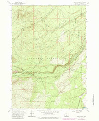
1962 Map of Shevlin Park
USGS Topo · Published 1984About this map
The Deschutes National Forest dominates this section of Central Oregon, revealing a complex network of water management and forest transit west of Bend. A sophisticated irrigation and hydroelectric infrastructure is visible through the Columbia Canal, Southern Canal, and the Tumalo Feed Canal, which draw from Tumalo Creek. This system of canals and an Aqueduct highlights the mid-century engineering required to manage water resources in the high desert landscape.
Find a feature on this map
23 named features on this map. Tap any name to fly to it.
Don’t see what you’re looking for? This feature index may not catch every label — zoom into the map to look around manually.
Map Details
Editions of this 1962 Shevlin Park Map
4 editions found
Other maps of this area

1926 · Bend
USGS Topo · 1:125,000

1929 · Bend
USGS Topo · 1:125,000

1929 · Three Sisters
USGS Topo · 1:125,000

1930 · Maiden Peak
USGS Topo · 1:125,000

1931 · Newberry Crater
USGS Topo · 1:125,000

1932 · Three Sisters
USGS Topo · 1:125,000

1934 · Maiden Peak
USGS Topo · 1:125,000

1935 · Newberry Crater
USGS Topo · 1:125,000

1955 · Crescent
USGS Topo · 1:250,000

1955 · Bend
USGS Topo · 1:250,000