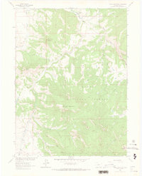
1962 Map of Shield Mountain
USGS Topo · Published 1973About this map
Three Forks Ranch sits at the confluence of several mountain waterways in this 1962 field-checked study of Routt County. The landscape is dominated by the high elevations of the Routt National Forest, where the headwaters of the Little Snake River are formed by the union of the North Fork, Middle Fork, and South Fork. The map reveals a remote geography of high peaks like Shield Mountain and Three Forks Mountain, accessible primarily by a network of Pack Trails and Jeep Trails.
Find a feature on this map
30 named features on this map. Tap any name to fly to it.
Don’t see what you’re looking for? This feature index may not catch every label — zoom into the map to look around manually.
Map Details
Editions of this 1962 Shield Mountain Map
4 editions found
Other maps of this area

1911 · Hahns Peak
USGS Topo · 1:125,000

1913 · Hahns Peak
USGS Topo · 1:125,000

1932 · Savery
USGS Topo · 1:96,000

1939 · Saratoga
USGS Topo · 1:125,000

1940 · Savery
USGS Topo · 1:125,000

1954 · Rawlins
USGS Topo · 1:250,000

1954 · Craig
USGS Topo · 1:250,000

1957 · Craig
USGS Topo · 1:250,000

1958 · Rawlins
USGS Topo · 1:250,000

1958 · Craig
USGS Topo · 1:250,000