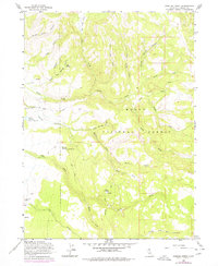
1963 Map of Shields Creek
USGS Topo · Published 1977About this map
Modoc National Forest dominates this mid-20th-century landscape, where a network of watercourses like Shields Creek and Parker Creek carve through the high terrain. The map reveals a remote outpost of land management and ranching, anchored by the Fitzhugh Guard Station and the Yankee Jim Ranch in the southern reaches. These sites, along with the Porter Reservoir and its spillway, point to a localized economy reliant on water management and forest service operations.
Find a feature on this map
32 named features on this map. Tap any name to fly to it.
Don’t see what you’re looking for? This feature index may not catch every label — zoom into the map to look around manually.
Map Details
Editions of this 1963 Shields Creek Map
4 editions found
Other maps of this area

1886 · Alturas
USGS Topo · 1:250,000

1892 · Alturas
USGS Topo · 1:250,000

1954 · Alturas
USGS Topo · 1:250,000

1958 · Alturas
USGS Topo · 1:250,000

1962 · Alturas
USGS Topo · 1:250,000

1962 · Davis Creek
USGS Topo · 1:62,500

1962 · Cedarville
USGS Topo · 1:62,500

1963 · Warren Peak
USGS Topo · 1:24,000

1963 · Little Juniper Reservoir
USGS Topo · 1:24,000

1963 · Shields Creek
USGS Topo · 1:24,000