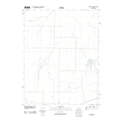
2009 Map of Shields NW
USGS Topo · Published 2009About this map
The Smoky Hill River winds across the northern landscape of this Lane County quadrangle, defining the local drainage and topography in an otherwise highly structured section of the Kansas High Plains. This 2009 survey reveals a strictly organized rural grid system, where long thoroughfares such as Laredo and Karl segment the territory into massive agricultural blocks. The southern portion of the sheet is anchored by the Shields Cemetery, a vital focal point for genealogical research in this sparsely settled region. Transport is dominated by named section-line roads including Newton Rd, Kaw Rd, and Pawnee Dr, which facilitate the movement of goods and people across the vast open spaces between established ranching and farming operations.
Find a feature on this map
13 named features on this map. Tap any name to fly to it.
Don’t see what you’re looking for? This feature index may not catch every label — zoom into the map to look around manually.
Map Details
Editions of this 2009 Shields NW Map
This is the sole edition of this map. No revisions or reprints were ever made.
Other maps of this area

1955 · Scott City
USGS Topo · 1:250,000

1958 · Scott City
USGS Topo · 1:250,000

1974 · Cheyenne Creek
USGS Topo · 1:24,000

1974 · Gove SW
USGS Topo · 1:24,000

1974 · Gove SE
USGS Topo · 1:24,000
1974 · Orion SE
USGS Topo · 1:24,000

1974 · Shields NW
USGS Topo · 1:24,000

1974 · Pendennis
USGS Topo · 1:24,000

1974 · Healy
USGS Topo · 1:24,000

1974 · Shields SE
USGS Topo · 1:24,000