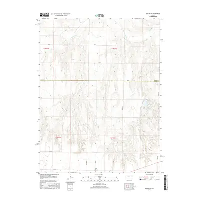
2015 Map of Shields NW
USGS Topo · Published 2015About this map
The Smoky Hill River carves through the northern reaches of this Kansas landscape, defining a network of drainage patterns including the tributary Plum Cr. This 2015 survey of the border between Gove and Lane Counties reveals a rural territory structured by section-line roads and sparse but significant landmarks. Near the southern edge of the sheet, the Shields Cem provides a primary point of interest for genealogists and local historians, sitting just off Laredo road. The transition from the river valley in the north to the high plains in the south is marked by a grid of named routes like Longhorn Rd, Newton Rd, and Pawnee Dr, which facilitate travel through the agricultural and pastoral lands of the High Plains. The topographical detail reveals the intricate break-in-slope as the plateau gives way to the river's drainage system.
Find a feature on this map
22 named features on this map. Tap any name to fly to it.
Don’t see what you’re looking for? This feature index may not catch every label — zoom into the map to look around manually.
Map Details
Editions of this 2015 Shields NW Map
This is the sole edition of this map. No revisions or reprints were ever made.
Other maps of this area

1955 · Scott City
USGS Topo · 1:250,000

1958 · Scott City
USGS Topo · 1:250,000

1974 · Cheyenne Creek
USGS Topo · 1:24,000

1974 · Gove SW
USGS Topo · 1:24,000

1974 · Gove SE
USGS Topo · 1:24,000
1974 · Orion SE
USGS Topo · 1:24,000

1974 · Shields NW
USGS Topo · 1:24,000

1974 · Pendennis
USGS Topo · 1:24,000

1974 · Healy
USGS Topo · 1:24,000

1974 · Shields SE
USGS Topo · 1:24,000