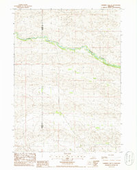
1985 Map of Shimmins Lake SE
USGS Topo · Published 1986About this map
The Dismal River carves a winding path through the heart of the Nebraska Sandhills in this mid-1980s provisional survey. This specific landscape is defined by the sharp boundary between Hooker County and Thomas County, where the river serves as the primary hydrological and topographical landmark. The map illustrates a complex network of unimproved roads and four-wheel-drive trails that navigate the shifting dune formations, providing an essential record of rural access before more modern developments. The absence of formal settlements highlights the isolated nature of this cattle country, where the terrain itself dictated the movement of ranchers and local inhabitants. For researchers, the detailed contour work reveals the intricate drainage patterns feeding into the river, a critical resource in this arid environment.
Find a feature on this map
2 named features on this map. Tap any name to fly to it.
Don’t see what you’re looking for? This feature index may not catch every label — zoom into the map to look around manually.
Map Details
Editions of this 1985 Shimmins Lake SE Map
This is the sole edition of this map. No revisions or reprints were ever made.
Other maps of this area

1948 · Thedford
USGS Topo · 1:62,500

1949 · Cody Lake
USGS Topo · 1:62,500

1950 · Thedford
USGS Topo · 1:62,500

1950 · Shimmins Lake
USGS Topo · 1:62,500

1951 · Tryon
USGS Topo · 1:62,500

1951 · Cody Lake
USGS Topo · 1:62,500

1954 · North Platte
USGS Topo · 1:250,000

1956 · North Platte
USGS Topo · 1:250,000

1957 · North Platte
USGS Topo · 1:250,000

1967 · North Platte
USGS Topo · 1:250,000