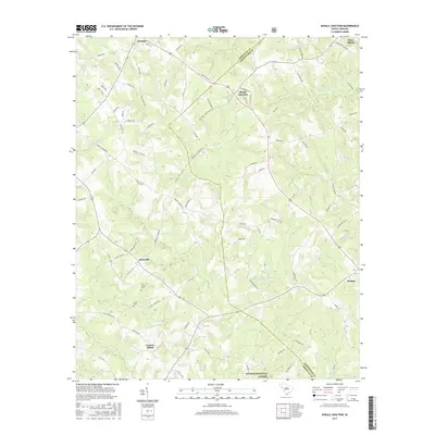
2017 Map of Shoals Junction
USGS Topo · Published 2017About this map
Shoals Junction and Arborville serve as central points in this portion of the South Carolina Upcountry, where the landscape is defined by the headwaters of the Long Cane Cr and Chickasaw Cr drainage basins. The map illustrates a rural settlement pattern rooted in small communities like Central-Shiloh and Donalds, connected by a network of farm roads and state highways that cross the Abbeville and Greenwood County line. Local history and genealogy are anchored by the presence of the Old Gilgal Cem and Gilgal Cem near Gilgal Church Rd, indicating a long-established community presence in the area. To the south, the boundary of the Sumter National Forest begins to shape the terrain, while the northeastern corner reaches toward the industrial and residential outskirts of Ware Shoals.
Find a feature on this map
89 named features on this map. Tap any name to fly to it.
Don’t see what you’re looking for? This feature index may not catch every label — zoom into the map to look around manually.
Map Details
Editions of this 2017 Shoals Junction Map
This is the sole edition of this map. No revisions or reprints were ever made.
Other maps of this area

1892 · Abbeville
USGS Topo · 1:125,000

1948 · Abbeville East
USGS Topo · 1:24,000

1948 · Abbeville West
USGS Topo · 1:24,000

1949 · Abbeville
USGS Topo · 1:24,000

1949 · Greenwood
USGS Topo · 1:24,000

1950 · Abbeville East
USGS Topo · 1:24,000

1954 · Greenville
USGS Topo · 1:250,000

1958 · Greenville
USGS Topo · 1:250,000
1970 · Honea Path
USGS Topo · 1:24,000
1971 · Cokesbury
USGS Topo · 1:24,000