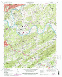
1979 Map of Shooks Gap
USGS Topo · Published 1988About this map
The confluence of the Holston River and the French Broad River forms the Tennessee River at the prominent Forks of the River, a landscape defined by industrial activity and established educational institutions. The Southern Railway tracks trace the riverbanks, serving resource-rich areas like Meades Quarry and Marbledale. To the south, Johnson Bible College anchors the community of Kimberlin Heights near the base of the Bays Mountains, while the Sevier Home sits along the McCall Branch in a valley characterized by numerous family burial grounds including Shook Cem and Neubert Cem. Suburban development from Knoxville extends into Burlington and Lake Forest, yet much of the terrain remains tied to its topographical features like Brown Mountain and the expansive Eastern State Wildlife Management Area.
Find a feature on this map
136 named features on this map. Tap any name to fly to it.
Don’t see what you’re looking for? This feature index may not catch every label — zoom into the map to look around manually.
Map Details
Editions of this 1979 Shooks Gap Map
4 editions found
Other maps of this area

1886 · Knoxville
USGS Topo · 1:125,000

1892 · Knoxville
USGS Topo · 1:125,000

1894 · Knoxville
USGS Topo · 1:125,000

1895 · Knoxville
USGS Topo · 1:125,000

1897 · Maynardville
USGS Topo · 1:125,000

1900 · Maynardville
USGS Topo · 1:125,000

1901 · Knoxville
USGS Topo · 1:125,000

1935 · Mascot
USGS Topo · 1:24,000

1935 · Knoxville
USGS Topo · 1:48,000

1935 · Straw Plains
USGS Topo · 1:48,000