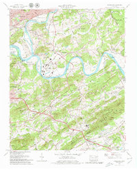
1979 Map of Shooks Gap
USGS Topo · Published 1979About this map
French Broad River and Holston River converge here to form the Tennessee River, creating a complex landscape of waterways and islands such as Boyd Island and Pickel Island. In the late 1970s, this area east of Knoxville maintains a distinct character where industrial sites like Meades Quarry and the Southern Railway corridor meet residential expansion in Marbledale and Asbury. The terrain is defined by the prominent ridges of Brown Mountain and Bays Mountain, which hem in the settlements of Shooks and Seymour. Genealogists will find a wealth of local history preserved in numerous burial grounds, including the Huckleberry Springs Ch + Cem and Armstrong Cem, alongside early community centers like the New Hopewell School + Church. The presence of the Downtown Island Airport and the Holston Hills Golf and Country Club illustrates the mid-century suburban and recreational development pushing outward from the city center.
Find a feature on this map
133 named features on this map. Tap any name to fly to it.
Don’t see what you’re looking for? This feature index may not catch every label — zoom into the map to look around manually.
Map Details
Editions of this 1979 Shooks Gap Map
4 editions found
Other maps of this area

1886 · Knoxville
USGS Topo · 1:125,000

1892 · Knoxville
USGS Topo · 1:125,000

1894 · Knoxville
USGS Topo · 1:125,000

1895 · Knoxville
USGS Topo · 1:125,000

1897 · Maynardville
USGS Topo · 1:125,000

1900 · Maynardville
USGS Topo · 1:125,000

1901 · Knoxville
USGS Topo · 1:125,000

1935 · Mascot
USGS Topo · 1:24,000

1935 · Knoxville
USGS Topo · 1:48,000

1935 · Straw Plains
USGS Topo · 1:48,000