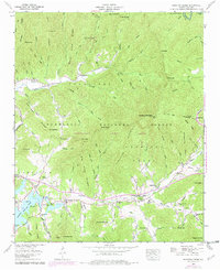
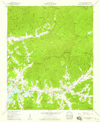
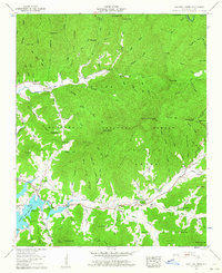
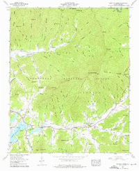
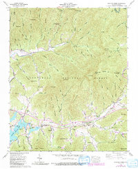
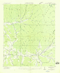
1957 Map of Shooting Creek
USGS Topo · Published 1978About this map
Tusquitee and the rural community of Shooting Creek anchor this mid-century view of Clay County, where the valley floor meets the steep reaches of Chunky Gal Mountain. The landscape is defined by the southern shoreline of Chatuge Lake, reflecting the influence of the Tennessee Valley Authority on the region's geography. A dense network of local landmarks provides a clear record of communal life, from the Shooting Creek School to numerous small houses of worship like Marshall Chapel and Union Chapel. Within the Nantahala National Forest, the topography is etched with family-named coves and gaps, including Joel Cove and Perry Gap. This map preserves the distribution of homesteads and burial sites, such as the Galloway Hill Cem, before modern development altered the remote character of these Appalachian foothills.
Find a feature on this map
78 named features on this map. Tap any name to fly to it.
Don’t see what you’re looking for? This feature index may not catch every label — zoom into the map to look around manually.
Map Details
Editions of this 1957 Shooting Creek Map
5 editions found
Other maps of this area

1886 · Dahlonega
USGS Topo · 1:125,000

1892 · Dahlonega
USGS Topo · 1:125,000

1896 · Dahlonega
USGS Topo · 1:125,000

1903 · Dahlonega
USGS Topo · 1:125,000

1935 · Osborn
USGS Topo · 1:24,000

1935 · Rainbow Springs
USGS Topo · 1:24,000
1935 · Shooting Creek
USGS Topo · 1:24,000

1935 · Burningtown Bald
USGS Topo · 1:24,000

1935 · Topton
USGS Topo · 1:24,000

1935 · Wayah Bald
USGS Topo · 1:48,000