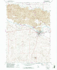
1971 Map of Shoshone
USGS Topo · Published 1993About this map
Shoshone serves as the focal point of this Idaho landscape, where the high desert meets an intricate network of early 20th-century water engineering. The confluence of the Big Wood River and the Little Wood River is heavily managed by a system of diversions, including the Milner Gooding Canal, numerous sections of Flume, and a Siphon. These features illustrate the vital role of irrigation in transforming the volcanic Lava terrain into a productive agricultural region.
Find a feature on this map
29 named features on this map. Tap any name to fly to it.
Don’t see what you’re looking for? This feature index may not catch every label — zoom into the map to look around manually.
Map Details
Editions of this 1971 Shoshone Map
3 editions found
Other maps of this area

1955 · Twin Falls
USGS Topo · 1:250,000

1955 · Hailey
USGS Topo · 1:250,000

1957 · Thorn Creek SE
USGS Topo · 1:24,000

1957 · Thorn Creek
USGS Topo · 1:62,500

1958 · Twin Falls
USGS Topo · 1:250,000

1959 · Hailey
USGS Topo · 1:250,000

1962 · Hailey
USGS Topo · 1:250,000

1971 · Shoshone SE
USGS Topo · 1:24,000

1971 · Dietrich
USGS Topo · 1:24,000

1971 · Tunupa
USGS Topo · 1:24,000