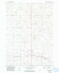
1971 Map of Shoshone SW
USGS Topo · Published 1993About this map
Agricultural infrastructure and water management define this high desert landscape on the border of Lincoln Co and Jerome Co. The intricate network of the Main Canal, numerous smaller Canal branches, and the Aqueduct illustrate the engineering required to sustain Idaho's Snake River Plain. Notable industrial landmarks such as the Midpoint Substation and a Pumping Station anchor the region's utilities. Compiled from 1969 aerial photography with 1980s updates, the map shows a landscape gridded by utility corridors like the Pipeline and a systematic road network including 700 North Road and 200 East Road. Localized water control is evidenced by the Diversion Dam and Siphon in the southeast, crucial for the regional D-4 ditch system and numerous wells that dot the terrain.
Find a feature on this map
34 named features on this map. Tap any name to fly to it.
Don’t see what you’re looking for? This feature index may not catch every label — zoom into the map to look around manually.
Map Details
Editions of this 1971 Shoshone SW Map
2 editions found
Other maps of this area

1950 · Jerome
USGS Topo · 1:24,000

1950 · Jerome
USGS Topo · 1:62,500

1955 · Twin Falls
USGS Topo · 1:250,000

1958 · Twin Falls
USGS Topo · 1:250,000

1964 · Falls City
USGS Topo · 1:24,000

1964 · Perrine
USGS Topo · 1:24,000

1971 · Shoshone SE
USGS Topo · 1:24,000

1971 · Dietrich
USGS Topo · 1:24,000

1971 · Tunupa
USGS Topo · 1:24,000
1971 · Gooding SE
USGS Topo · 1:24,000