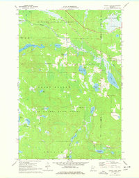
1970 Map of Shovel Lake
USGS Topo · Published 1978About this map
The Soo Line railroad cuts diagonally across a landscape defined by its complex hydrology at the boundary of Cass and Aitkin counties. This 1970 field-checked survey reveals an area heavily shaped by the glacial geography of the Chippewa National Forest and Land O' Lakes State Forest. The presence of a Townhall and Lakeview Cem near the shores of Windy Lake suggests a focused point of community life amidst the dense network of water bodies like Shovel Lake and Little Thunder Lake.
Find a feature on this map
28 named features on this map. Tap any name to fly to it.
Don’t see what you’re looking for? This feature index may not catch every label — zoom into the map to look around manually.
Map Details
Editions of this 1970 Shovel Lake Map
2 editions found
Other maps of this area

1953 · Duluth
USGS Topo · 1:250,000

1954 · Hibbing
USGS Topo · 1:250,000

1957 · Hibbing
USGS Topo · 1:250,000

1958 · Hibbing
USGS Topo · 1:250,000

1958 · Duluth
USGS Topo · 1:250,000

1964 · Hibbing
USGS Topo · 1:250,000

1970 · Edna Lake
USGS Topo · 1:24,000

1970 · Big Thunder Peak
USGS Topo · 1:24,000

1970 · Shovel Lake
USGS Topo · 1:24,000
1970 · Roosevelt Lake
USGS Topo · 1:24,000