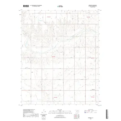
2018 Map of Shrewder
USGS Topo · Published 2018About this map
Salt Fork Red River meanders across this corner of Harmon County, defining a landscape marked by ranching and small-scale water management. The terrain is dotted with private water resources like Claude Seymour Reservoir and the Danny E Hill Reservoir, reflecting the necessity of irrigation in this semi-arid region. Small community centers such as Ron and Shrewder appear as focal points for the surrounding rural sections, connected by a network of sectional roads. Local history is anchored at the Tea Cross Cem, a significant marker of early settlement patterns in the Oklahoma southwest. Tributaries like Turkey Cr and Cave Cr carve through the landscape, illustrating the drainage patterns that have shaped the development of these plains.
Find a feature on this map
24 named features on this map. Tap any name to fly to it.
Don’t see what you’re looking for? This feature index may not catch every label — zoom into the map to look around manually.
Map Details
Editions of this 2018 Shrewder Map
This is the sole edition of this map. No revisions or reprints were ever made.
Other maps of this area

1955 · Lawton
USGS Topo · 1:250,000

1961 · Hollis
USGS Topo · 1:62,500

1971 · Russell
USGS Topo · 1:24,000
1971 · Madge
USGS Topo · 1:24,000

1971 · Vinson
USGS Topo · 1:24,000
1971 · Mc Knight
USGS Topo · 1:24,000

1971 · Mc Queen
USGS Topo · 1:24,000

1971 · Reed
USGS Topo · 1:24,000
1971 · Shrewder
USGS Topo · 1:24,000

1975 · Hollis NE
USGS Topo · 1:24,000