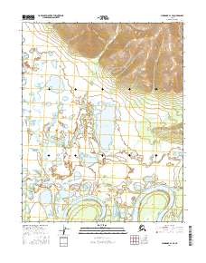
2016 Map of Shungnak A-1 SE
USGS Topo · Published 2016About this map
The Koyukuk River meanders through the southern portion of this interior Alaska landscape, creating a complex network of sloughs and oxbows within the Yukon-Koyukuk region. To the north, the terrain transitions into a more defined upland area, while the central lowlands are dominated by substantial water bodies including Solsmunket Lake and Tsbantotloden Lake. The Dakli River flows through the western section, eventually connecting toward the larger river system. This 2016 survey illustrates the intricate relationship between the region's hydrography and the surrounding elevation, where Duck Lake sits among a cluster of smaller, unnamed ponds and seasonal wetlands. The map provides a detailed view of the Public Land Survey System grid across townships like t8n r13e and t7n r13e, marking the administrative boundaries in this largely uninhabited wilderness.
Find a feature on this map
11 named features on this map. Tap any name to fly to it.
Don’t see what you’re looking for? This feature index may not catch every label — zoom into the map to look around manually.
Map Details
Editions of this 2016 Shungnak A-1 SE Map
This is the sole edition of this map. No revisions or reprints were ever made.
Other maps of this area

1951 · Shungnak
USGS Topo · 1:250,000

1951 · Kateel River
USGS Topo · 1:250,000

1951 · Hughes
USGS Topo · 1:250,000

1951 · Melozitna
USGS Topo · 1:250,000

1954 · Kateel River D-1
USGS Topo · 1:63,360

1954 · Melozitna D-6
USGS Topo · 1:63,360

1955 · Shungnak
USGS Topo · 1:250,000

1955 · Kateel River
USGS Topo · 1:250,000

1956 · Hughes
USGS Topo · 1:250,000

1956 · Melozitna
USGS Topo · 1:250,000