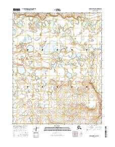
2016 Map of Shungnak B-5 NE
USGS Topo · Published 2016About this map
The Selawik River meanders across this Arctic landscape, creating a complex network of oxbow lakes and wetlands within the Northwest Arctic region. This environment is characterized by its dynamic hydrology, where the main river channel and smaller tributaries like Ingruksukruk Cr and Shovel Cr continuously reshape the low-lying terrain. The map provides a detailed view of the Public Land Survey System (PLSS) grid, documenting townships such as t13n r3e and t12n r4e, which are essential for understanding land divisions and resource management in this part of Alaska. The abundance of unnamed lakes and marshy areas between the primary watercourses illustrates a classic subarctic drainage pattern where water dominates the geography during the 2016 survey period.
Find a feature on this map
9 named features on this map. Tap any name to fly to it.
Don’t see what you’re looking for? This feature index may not catch every label — zoom into the map to look around manually.
Map Details
Editions of this 2016 Shungnak B-5 NE Map
This is the sole edition of this map. No revisions or reprints were ever made.
Other maps of this area

1951 · Shungnak
USGS Topo · 1:250,000

1955 · Shungnak
USGS Topo · 1:250,000

1964 · Shungnak
USGS Topo · 1:250,000

1985 · Shungnak B-4
USGS Topo · 1:63,360
1985 · Shungnak B-5
USGS Topo · 1:63,360
1985 · Shungnak C-5
USGS Topo · 1:63,360
1985 · Shungnak C-4
USGS Topo · 1:63,360
2015 · Shungnak B-5 NW
USGS Topo · 1:25,000
2015 · Shungnak C-5 SW
USGS Topo · 1:25,000
2016 · Shungnak B-5 SE
USGS Topo · 1:25,000