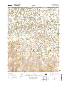
2015 Map of Shungnak C-5 NW
USGS Topo · Published 2015About this map
Kugarak River meanders across this northern landscape, defining the character of a region where water and marshland dominate the geography. This 2015 study of the Northwest Arctic illustrates a complex network of thaw lakes and ponds that vary in density across the townships of t16n r2e, t16n r3e, and t15n r3e. The southern portion of the map transitions into higher ground, showing a distinct change in elevation where the myriad small water bodies give way to more defined topographical contours. This map captures the natural drainage patterns and seasonal wetlands of the Arctic wilderness prior to any significant modern infrastructure development, serving as a primary reference for the hydrology of this specific corridor in the Shungnak area.
Find a feature on this map
7 named features on this map. Tap any name to fly to it.
Don’t see what you’re looking for? This feature index may not catch every label — zoom into the map to look around manually.
Map Details
Editions of this 2015 Shungnak C-5 NW Map
This is the sole edition of this map. No revisions or reprints were ever made.
Other maps of this area

1951 · Shungnak
USGS Topo · 1:250,000

1955 · Shungnak
USGS Topo · 1:250,000

1955 · Shungnak D-6
USGS Topo · 1:63,360

1955 · Shungnak D-5
USGS Topo · 1:63,360

1964 · Shungnak
USGS Topo · 1:250,000
1985 · Shungnak C-6
USGS Topo · 1:63,360
1985 · Shungnak C-5
USGS Topo · 1:63,360
2015 · Shungnak D-6 SE
USGS Topo · 1:25,000
2015 · Shungnak D-5 SE
USGS Topo · 1:25,000
2015 · Shungnak C-6 NE
USGS Topo · 1:25,000