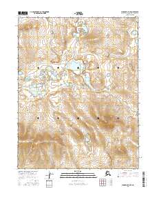
2016 Map of Shungnak C-5 SE
USGS Topo · Published 2016About this map
The Kawichiark River winds through this expanse of the Northwest Arctic, carving a path through a landscape defined by intricate wetland complexes and subtle topographic rises. This 2016 survey illustrates the remote riverine environment within the boundaries of t14n r3e, t14n r4e, t13n r3e, and t13n r4e. The mapping of these survey townships reveals a complex hydrology of small lakes and seasonal ponds that fluctuate with the Arctic seasons. This document serves as a precise record of the shoreline and drainage patterns before potential shifts in the permafrost or hydrological cycle alter the course of the local waterways.
Find a feature on this map
5 named features on this map. Tap any name to fly to it.
Don’t see what you’re looking for? This feature index may not catch every label — zoom into the map to look around manually.
Map Details
Editions of this 2016 Shungnak C-5 SE Map
This is the sole edition of this map. No revisions or reprints were ever made.
Other maps of this area

1951 · Shungnak
USGS Topo · 1:250,000

1955 · Shungnak
USGS Topo · 1:250,000

1964 · Shungnak
USGS Topo · 1:250,000

1985 · Shungnak B-4
USGS Topo · 1:63,360
1985 · Shungnak B-5
USGS Topo · 1:63,360
1985 · Shungnak C-5
USGS Topo · 1:63,360
1985 · Shungnak C-4
USGS Topo · 1:63,360
2015 · Shungnak B-5 NW
USGS Topo · 1:25,000
2015 · Shungnak C-5 NW
USGS Topo · 1:25,000
2015 · Shungnak C-5 SW
USGS Topo · 1:25,000