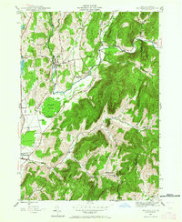
1944 Map of Shushan
USGS Topo · Published 1964About this map
Shushan and the winding Batten Kill define the landscape of Washington County during the mid-1940s. The settlement pattern follows the river valley and the tracks of the Delaware and Hudson railroad, which provided a vital connection for agricultural and timber transport. To the south, Cambridge marks the convergence of early regional roads, while smaller hamlets like Eagleville and Pumpkin Hook reflect the era’s rural network of self-sufficient communities.
Find a feature on this map
45 named features on this map. Tap any name to fly to it.
Don’t see what you’re looking for? This feature index may not catch every label — zoom into the map to look around manually.
Map Details
Editions of this 1944 Shushan Map
3 editions found
Other maps of this area

1894 · Equinox
USGS Topo · 1:62,500

1895 · Cambridge
USGS Topo · 1:62,500

1896 · Equinox
USGS Topo · 1:62,500

1897 · Hoosick
USGS Topo · 1:62,500

1898 · Cambridge
USGS Topo · 1:62,500

1898 · Bennington
USGS Topo · 1:62,500

1900 · Taconic
USGS Topo · 1:125,000

1900 · Equinox
USGS Topo · 1:62,500

1901 · Cambridge
USGS Topo · 1:62,500

1903 · Mettawee
USGS Topo · 1:125,000