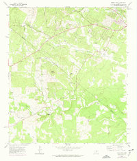
1968 Map of Signal Hill
USGS Topo · Published 1974About this map
Cedar Valley and the surrounding ranchlands of the Texas Hill Country define this late 1960s landscape, positioned along the border of Travis and Hays counties. The terrain is characterized by prominent limestone elevations like Signal Hill and the distinct formation of Friday Mountain, with numerous drainages including Slaughter Creek and Bear Creek carving through the plateau. Several established family holdings, such as Koenig Ranch, Sawyer Ranch, and Spillar Ranch, suggest a region still deeply rooted in traditional land use, even as infrastructure like pipelines and a growing network of roads like Fitzhugh Road began to expand. Social centers are few but significant for local history, notably the Friendship Ch and a Boys Camp located near the southern county line. Genealogists will find particular value in the locations of the Oliver Cem and Johnson Cem, which serve as physical markers of the area's early settlement families.
Find a feature on this map
40 named features on this map. Tap any name to fly to it.
Don’t see what you’re looking for? This feature index may not catch every label — zoom into the map to look around manually.
Map Details
Editions of this 1968 Signal Hill Map
Other maps of this area

1887 · Blanco
USGS Topo · 1:125,000

1894 · Blanco
USGS Topo · 1:125,000

1896 · Austin
USGS Topo · 1:125,000

1897 · Austin
USGS Topo · 1:125,000

1910 · Austin
USGS Topo · 1:125,000

1932 · Mt. Bonnell
USGS Topo · 1:62,500

1954 · Austin West
USGS Topo · 1:24,000

1954 · Llano
USGS Topo · 1:250,000

1954 · Austin
USGS Topo · 1:250,000

1955 · Llano
USGS Topo · 1:250,000