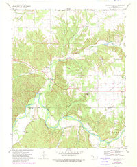
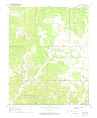
1972 Map of Siloam Springs NW
USGS Topo · Published 1982About this map
Illinois River meanders through the heart of this landscape, carving through the terrain to create Fidlers Bend and joining various tributaries such as Flint Creek and Rock Branch. The 1972 survey, with revisions updated to 1982, shows a rural network of small communities and homesteads across Moseley Prairie. For genealogists and local historians, the presence of institutions like Union Ch, Moseley Sch, and the Crittenden Cem provides concrete locations for early Delaware County social life. Transportation infrastructure is seen in transition near the Adair County line, with a segment of road marked under construction. The topography is defined by numerous hollows, including Calunchety Hollow and Fivemile Hollow, which feed into the primary river system, reflecting the traditional drainage patterns that dictated early settlement at places like Beckwith.
Find a feature on this map
32 named features on this map. Tap any name to fly to it.
Don’t see what you’re looking for? This feature index may not catch every label — zoom into the map to look around manually.
Map Details
Editions of this 1972 Siloam Springs NW Map
2 editions found
Other maps of this area

1899 · Siloam Springs
USGS Topo · 1:125,000

1903 · Siloam Springs
USGS Topo · 1:125,000

1904 · Siloam Springs
USGS Topo · 1:125,000

1954 · Tulsa
USGS Topo · 1:250,000

1958 · Tulsa
USGS Topo · 1:250,000

1963 · Tulsa
USGS Topo · 1:250,000

1971 · Jay SE
USGS Topo · 1:24,000
1971 · Cherokee City
USGS Topo · 1:24,000
1971 · Colcord
USGS Topo · 1:24,000
1972 · Chance
USGS Topo · 1:24,000