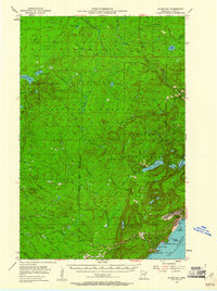
1954 Map of Silver Bay
USGS Topo · Published 1961About this map
Industrial expansion along the North Shore of Lake Superior defines this mid-century survey, specifically highlighting the development of Silver Bay. The map documents a pivotal moment for the region as the Mining Company facilities, including a large Powerplant and specialized Sewage Disposal system, emerge on the shoreline to support taconite processing. This burgeoning industrial site stands in contrast to the surrounding Superior National Forest, where the landscape remains dominated by a dense network of water bodies like Lax Lake, Cloquet Lake, and the winding course of the Baptism River.
Find a feature on this map
51 named features on this map. Tap any name to fly to it.
Don’t see what you’re looking for? This feature index may not catch every label — zoom into the map to look around manually.
Map Details
Editions of this 1954 Silver Bay Map
3 editions found
Other maps of this area

1953 · Whyte
USGS Topo · 1:62,500

1954 · Greenwood Lake
USGS Topo · 1:62,500

1954 · Silver Bay
USGS Topo · 1:62,500

1954 · Two Harbors
USGS Topo · 1:250,000

1955 · Isabella
USGS Topo · 1:62,500

1955 · Cramer
USGS Topo · 1:62,500

1956 · Split Rock Point
USGS Topo · 1:24,000

1956 · Finland
USGS Topo · 1:24,000

1956 · Finland
USGS Topo · 1:62,500

1956 · Illgen City
USGS Topo · 1:24,000