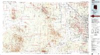
1994 Map of Silver Bell Mountains
USGS Topo · Published 1994About this map
The Silver Bell Mountains and surrounding desert basins define this high-altitude 1994 topographic study of Pima County. Industrial activity is prominent at the Silver Bell Mine, where extensive Tailings Ponds and open pits mark the landscape north of the Roskruge Mountains. To the east, the agricultural and transport corridor along the Southern Pacific RR connects Marana, Rillito, and Cortaro near the Santa Cruz River.
Find a feature on this map
48 named features on this map. Tap any name to fly to it.
Don’t see what you’re looking for? This feature index may not catch every label — zoom into the map to look around manually.
Map Details
Editions of this 1994 Silver Bell Mountains Map
2 editions found
Other maps of this area

1904 · Patagonia
USGS Topo · 1:125,000

1904 · Tucson
USGS Topo · 1:125,000

1905 · Patagonia
USGS Topo · 1:125,000

1905 · Tucson
USGS Topo · 1:125,000

1911 · Winkelman
USGS Topo · 1:125,000

1913 · Winkelman
USGS Topo · 1:125,000

1920 · Arivaca
USGS Topo · 1:125,000

1925 · Samaniego Peak
USGS Topo · 1:62,500

1925 · San Xavier
USGS Topo · 1:62,500

1926 · Helvetia
USGS Topo · 1:62,500