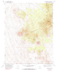
1971 Map of Silver King Mtn
USGS Topo · Published 1990About this map
The Schell Creek Range dominates this corner of the Great Basin, where the high peaks of the Nevada interior meet the administrative boundary between Nye and Lincoln counties. This 1970s survey captures a landscape defined by its aridity and geological potential, centered on the towering Silver King Mountain and the nearby Silver King Pass. While the terrain appears largely unsettled, evidence of human activity is recorded through a network of Jeep Trails and a specific Prospect located on the northern slopes of Burnt Peak. The inclusion of the Burnt Peak Well (Dry) provides a stark detail of the challenges facing those who worked this land, marking a failed or seasonal water source in an environment where moisture was a critical resource for mining and ranching interests.
Find a feature on this map
14 named features on this map. Tap any name to fly to it.
Don’t see what you’re looking for? This feature index may not catch every label — zoom into the map to look around manually.
Map Details
Editions of this 1971 Silver King Mtn Map
3 editions found
Other maps of this area

1956 · Lund
USGS Topo · 1:250,000

1960 · Lund
USGS Topo · 1:250,000

1969 · Gap Mountain
USGS Topo · 1:24,000
1971 · Silver King Mtn SW
USGS Topo · 1:24,000

1971 · Bailey Wash
USGS Topo · 1:24,000
1971 · Timber Mtn Pass NE
USGS Topo · 1:24,000

1971 · Silver King Mtn
USGS Topo · 1:24,000

1971 · Sidehill Pass
USGS Topo · 1:24,000
1971 · Silver King Well
USGS Topo · 1:24,000
1971 · Timber Mtn Pass East
USGS Topo · 1:24,000