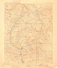
1897 Map of Silverton
USGS Topo · Published 1897About this map
The town of Silverton serves as the industrial and transportation anchor for this high-altitude mining district during the late nineteenth-century boom. Narrow-gauge rail lines, including the Denver & Rio Grande R. R. and the Silverton R. R., thread through deep canyons to reach isolated camps and ore-processing sites. The landscape is densely packed with extractive infrastructure, from the Stoiber Smelter on the valley floor to the Yankee Girl Mine and Sunnyside Mine perched in the surrounding basins.
Find a feature on this map
155 named features on this map. Tap any name to fly to it.
Don’t see what you’re looking for? This feature index may not catch every label — zoom into the map to look around manually.
Map Details
Editions of this 1897 Silverton Map
2 editions found
Other maps of this area

1897 · Telluride
USGS Topo · 1:62,500

1897 · Silverton
USGS Topo · 1:62,500

1898 · Engineer Mountain
USGS Topo · 1:62,500

1900 · Engineer Mountain
USGS Topo · 1:62,500

1900 · Needle Mountains
USGS Topo · 1:62,500

1901 · Silverton
USGS Topo · 1:62,500

1902 · Needle Mountains
USGS Topo · 1:62,500

1902 · Silverton
USGS Topo · 1:62,500

1902 · Ouray
USGS Topo · 1:62,500

1903 · Lake City
USGS Topo · 1:62,500