
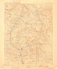
1897 Map of Silverton
USGS Topo · Published 1897About this map
Silverton serves as the industrial and transportation hub for this 1895 survey, where the Denver & Rio Grande R.R. meets the Denver & Silverton Line and the steep Silverton and Red Mountain R.R. The landscape is defined by an intensive concentration of late-19th-century mining infrastructure, featuring major operations like the Sunnyside Mine, the Stoiber Smelter, and the massive Revenue Tunnel. Numerous smaller mining camps and processing sites are scattered across the high basins and gulches, including Mineral Point, Animas Forks, and Eureka.
Find a feature on this map
151 named features on this map. Tap any name to fly to it.
Don’t see what you’re looking for? This feature index may not catch every label — zoom into the map to look around manually.
Map Details
Editions of this 1897 Silverton Map
2 editions found
Other maps of this area

1897 · Telluride
USGS Topo · 1:62,500

1898 · Engineer Mountain
USGS Topo · 1:62,500

1900 · Engineer Mountain
USGS Topo · 1:62,500

1900 · Needle Mountains
USGS Topo · 1:62,500

1901 · Silverton
USGS Topo · 1:62,500

1902 · Needle Mountains
USGS Topo · 1:62,500

1902 · Silverton
USGS Topo · 1:62,500

1902 · Ouray
USGS Topo · 1:62,500

1903 · Lake City
USGS Topo · 1:62,500

1904 · Ouray
USGS Topo · 1:62,500