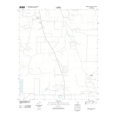
2010 Map of Simmons Bottom
USGS Topo · Published 2010About this map
Carter Settlement and the small community of Simmons Bottom anchor this portion of Liberty County, revealing a landscape defined by the winding course of Luce Bayou. Located northwest of Dayton, the area is characterized by its transition from wooded bottomlands to rural homesteads and newer residential developments. Local genealogy is rooted at the Ryan Cemetery, situated near the intersection of Co RD 303 and Co RD 3001.
Find a feature on this map
35 named features on this map. Tap any name to fly to it.
Don’t see what you’re looking for? This feature index may not catch every label — zoom into the map to look around manually.
Map Details
Editions of this 2010 Simmons Bottom Map
This is the sole edition of this map. No revisions or reprints were ever made.
Other maps of this area

1916 · Huffman
USGS Topo · 1:24,000

1920 · Huffman
USGS Topo · 1:31,680

1943 · Liberty
USGS Topo · 1:125,000

1954 · Beaumont
USGS Topo · 1:250,000

1955 · Rayburn
USGS Topo · 1:62,500

1955 · Liberty
USGS Topo · 1:62,500

1957 · Beaumont
USGS Topo · 1:250,000

1958 · Cleveland
USGS Topo · 1:24,000

1959 · Plum Grove
USGS Topo · 1:24,000
1960 · Huffman
USGS Topo · 1:24,000